14. Mai 2016
Welcome to Scotland, Revisited
 Back from an extraordinary hiking trip to Scotland. Soaring temperatures, not a single drop of rain, few midges, outstanding panoramas were just some of the highlights of my second multi-day hiking adventure into the West Highlands.
Day 1: To Edinburgh
London and Edinburgh are connected very well through a fast train service along the east coast. Having packed last minute, I was very happy to have a checklist at hand and hence got most things with me that I wanted to [1].
On the train, I was joined by a horde of guys who were on their way to Newcastle, getting themselves drunk on the way their (unfortunately, the train is just slow enough to allow several pints getting downed between King’s Cross and Newcastle). While I don’t them having a bit of fun themselves, they went over the top by not only singing at their loudest but also hammering against the windows for the lack of other available percussion instruments. Most other passengers ignored them professionally, and I was to lazy to complain too and commented the scene only once with a solid insult – which the horde ignored professionally, probably to my own benefit even though they did not look like seeking violence. In Newcastle, it was over. So I thought; a group of women who was boarding decided to get drunk on the way to Edinburgh, replacing the gung-ho singing by laughter at what is an intolerably high frequency for my ears. Well, end of rant, wasn’t I about to write about Scotland?
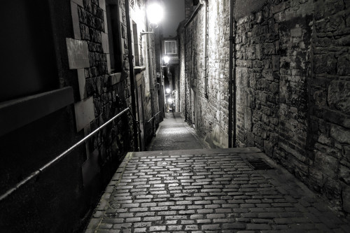
A close at the Royal Mile in Edinburgh.
In Edinburgh, I was waiting for Peter, a friend with whom I was about to travel to the Highlands. In the meantine, in a random pub I made friends with a local who just told me his “wife had just married today”. In those strange times it is probably good to have a pint with a random stranger like me and then to part ways again. At the occasion, I got a few recommendations for Edinburgh. The friendly chap also treated me to a bottle of Innis & Gunn Original, an oak-flavoured beer I quite enjoyed.
Day 2: Warming up on Arthur’s Seat
Arthur’s Seat, an ancient volcano in Edinburgh, was one of today’s destinations. A gentle walk with a fine view over the city, which was wearing its best spring outfit. And Haggis for dinner. Obviously.
Flowers in Edinburgh.
Day 3: To Glenfinnan by rail
It was my second time in Scotland. In the blog post about my first trip, I wrote that I would take the train this time instead of the car. And so we did. We bought tickets for the West Highland line in Edinburgh. The lady at the counter advised us to get a ticket to Lochailort and return which would allow us to stop on the journey back as often as we wanted. I was wondering about how request stops worked where the train would only come to a halt on request. The lady just laughed: “These trains don’t go at 100 mph.” So it is just about waving to the train driver and he’ll stop.
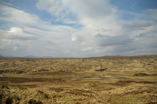
The vast emptiness of Rannoch Moor.
The route from Glasgow along the West Highland line was indeed as scenic as people told me. The views are rarely obstructed and the train passed outstandingly pretty areas – Loch Lomond, Rannoch Moor, Loch Eil. We passed the Glenfinnan Viaduct (which nowadays is apparently mostly known as the “Harry Potter Viaduct”) and got off at Glenfinnan Station where we were greeted by a local who gave us the valuable hint to take a footpath starting behind the Glenfinnan Sleeping Car as a shortcut to the viaduct.
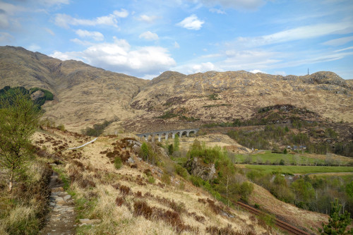
The Glenfinnan Viaduct.
Unlike most of the (few) other people, we were not heading for the viaduct only but were making it five kilometers into the valley, where we peeked into the friendly Corryhully Bothy (bothies are shelters that are free to use) which was yet empty, pitched our tent in the sunny evening, and were welcomed by Alistair, who told us he was managing the whole valley, and who warned us of hot weather the day after. Not at such a remote place after all. Yet.
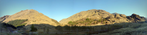
Panorama of Glen Finnan.
Day 4: Walking the Horseshoe
Rising fairly early, we started our way along the Glenfinnan circuit, as described in the book “Great Mountain Days in Scotland” [2] up the mountains Sgurr nan Coireachan, Beinn Garbh, and Sgurr Thuilm. On hindsight, it makes sense to look at the meanings of Gaelic words commonly seen in hill names [3]. In the morning, there was as far as I could see no one else on the mountains – just us. By the afternoon, we met a lone hillwalker who greeted us politely and continued. Shortly thereafter, we met yet another hillwalker near the top of Sgurr Thuilm who explained that he was here for filming Munros – and that the movies were available on http://www.munrodrone.com. Soon we saw his quadcopter hover above the summit despite of the strong wind. Our journey might thus have been documented by a quadcopter…
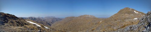
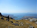
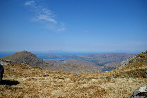
Outstanding view with high visibility and clear sky.
The day was sunny, cloudless, and indeed hot with temperatures well above 20 degrees. In May. In Scotland. Fortunately, my checklist had included sun screen with SPF 50, and the Buff I brought served as a so-so replacement for the hat I did not bring. Water was also fairly scarce further up. It was hence a good idea to fill multiple bottles in the valley where water was plenty. As we left tent and other stuff behind, we did not need to carry much else. Which was good for the first day out in the Highlands.
Smoke rising from the valley
On the ridge, we saw quite a lot of smoke rising in the valley opposite where we had our tent, and it also started to smell like burnt wood. Was it a wildfire? Or just people burning wood on purpose? We could not do much so ignored it.
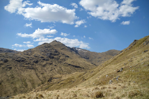
Sgurr nan Coireachan
At the end, we did not complete the whole circuit, which was very challenging, might well have been too much for the first day, and would have been very strenuous in the afternoon heat. Instead, we returned fairly early to our camp and used the cool water from the stream to recover from the hillwalking. Almost no midges around, but plenty of ticks, which made me think how to prepare for that annoyance.
Food-wise, we were equipped with a rock-solid Trangia camping cooker, which had never failed me so far – even in windy, rainy conditions. As usually, I preferred to bring simple & quick meals, so once again I brought some Mac’n‘Cheese and some parboiled rice. To spice things up a little bit and add more desperately-needed calories, I always added olive oil & salt – every day. Olive oil makes all dishes taste a bit similar, but I find that it hugely improves taste and nutritional value – so I do not care.
Day 5: First day of the mountain traverse
Fully geared with all of our equipment, with map & compass, we set off to return to Glenfinnan and start our mountain traverse from Glenfinnan to Lochailort. The traverse is said to take more than 12 hours and 25 km, so we split the traverse into two sections. Which was wise because the book assumes fairly fast and very strong hillwalkers.
Again, it was sunny and no clouds in sight. Carefully tracing our path through Glenfinnan and along Loch Shiel using map, route description, and compass, we made progress towards the point where the ascent was to start. It is very important to check the map often and always compare expectations with observations to pick up any discrepancies as early as possible.
We make it past a hotel, a boat house, a stable, along the shoreline of Loch Shiel across a headland (I cursed myself at that point for not having thought of painstakingly translating every single of the geographical terms in the route description; fortunately, most of the words I knew and “headland” could be inferred from context). There was no path, which we were warned by a local and knew from the route description. Hence, as advised in the book, we left Loch Shiel and started climbing up the grassy mountain flank.
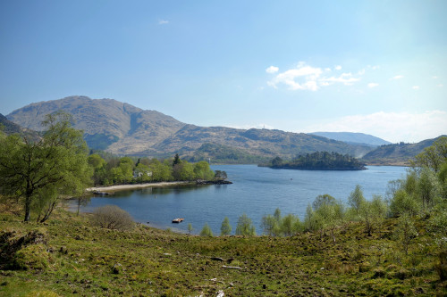
Loch Shiel
In low visibility, I would have aborted the mission as it would have made matching terrain features with the map hard. But the visibility was excellent, and streams, cols, smaller tops, streams, and lakes were reasonably easy to match against the map and the compass gave additional assurance about the right directions. Also, once we were past the point of no return, we would still have our tent with us and also been able to descend to Essan Bothy halfway to abort the traverse after day one if the weather conditions were about to worsen significantly.
Peter and I decided to continue our quest and we finished the relentless ascent up to Beinn Odhar Mhor, the first summit of the day. Enjoying the stunning panorama, we continued as planned to the second summit along a fairly easy ridge before descending into a col. The next summit, however, turned out to be tough. Our legs were already a bit tired and the ascent was on a grassy flank steep enough to effectively prevent most attempts to criss-cross; we ended up mostly walking up in a straight line to the top. What a drudgery towards the end of the day!
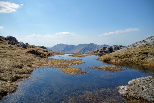
Infinity pool
We finally made it down into the next col (still high up, a desolate boggy place) where it was time to look for a suitable tentsite. Not so easy, given that there are so many criteria for a good spot. Windstill, if possible. Dry. Soft. No rocks. With water access. And level, above all. Still, there were plenty of spots and we finally ended up finding a dry, level, soft spot next to a stream just before reaching the col. But only protected from wind on two sides. The strong winds were a bit of a problem in combination with the herrings not gripping too strong in the soft soil. Hence, I wanted to use a few stones as weights to make up for the lack of grip. Trick: stones of all sizes that aren’t stuck in the ground can be found in burns. So that problem was solved as well.
The days are long in May, and we had plenty of time to prepare more food with the unfailing Trangia while watching the sun set behind the mountains, painting the golden, green, but paltry walls of the hills around us. Not a single soul in view, not a single sign of life in the valley, just the echo of the Jacobite steam train managed to reach our remote and lonely accommodation for the night.
Day 6: Second day of the mountain traverse
We ate our last portions of porridge, sweetened by some incredibly overpriced strawberry jam we had bought in a tourist shop in Edinburgh; the small portion of the jam jars and the prospects of porridge cooked with water only however convinced us that the return warranted the investment.
Replenished, we made our way towards Drum Fiaclach, a craggy mountain. We took the suggestion by the book to circle around the mountain along the contour lines and approach it from the north, as it was advertised to be less steep, and both map and observation corroborated this. Indeed, this way we managed to avoid easy scrambling and most parts of the ridge towards Drum Fiaclach.
From the summit, the ridge became wide and easy to walk and we enjoyed the view on the surrounding hills – and the Atlantic Ocean! Breathtaking. I remember a similar feeling from my hillwalking days in Hong Kong, where the panorama would include the mushroom-like skyscrapers cuddling around the hills, surrounded by the blue sea. Visibility was great – and we could well see the Isle of Rum with its distinctive contours in the ocean.
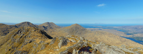
View towards the Rhois-Beinn group
Finally, as predicted by our guidebook, we found a trail. Signs of civilization! And then, two sheep appeared and sensed our presence. But what sheep were they?Big balls of wool; haven’t been sheared for a long time. Probably run-away sheep, I thought.
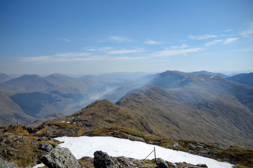
View towards An Stac and the Isle of Rum
Then, we worked our way to Sgurr na Ba Glaise, which we reached fairly easily by continuing along the wide ridge. The drop to the left was impressive. At the next col, we left our backpacks and approached another hill for the sake of having the view over the ocean. At this point, we could see the first two people for the day on the neighboring hill but as we turned back to our backpacks, we did not wait to say hello. Instead, we descended steeply down just to seek our way up An Stac, which offered maybe the best panorama of the day – and the baseline was already high. Views over Loch Ailort, Arisaig, Isle of Rum, the Atlantic, Ben Nevis, you name it. We spent quite some time admiring the view before descending on ankle-bending grassland to our destination: Lochailort.

View on Loch Ailort, the Isle of Rum and the Atlantic from the summit of An Stac
At Lochailort Station (which had the smallest Station Car Park I had ever seen), we flagged down the train and given that we were running out on food, we made it back to Fort William (Mallaig was another option) in the evening. In Fort William – after three days out in the wilderness – we got a bit of a culture shock when eating out in a pub before pitching the tent at a random spot in the hills beyond.
Day 7: Up Ben Nevis
I did not bring my map of the Ben Nevis area and did not really intend to buy a new one. We decided to hike up Ben Nevis, the highest mountain of the British Isles, along the Pony Trail, the easiest of all ascent routes. I had been up Ben Nevis before, and the trail is well marked but we were not sure of the snow conditions. However, turning around is possible (and often a good idea, mind that!). In the particular case, there were still snow sections, which however were passable as they were in sections that were not too steep or would end at any drops.
The view of Ben Nevis was not as good as the ones we had on the previous days, partially because the top is so flat, and partially because visibility had decreased due to dust in the air – still it was sunny. A ham radio operator with portable equipment was on the top and saying hello from Ben Nevis to other radio operators – quite interesting.
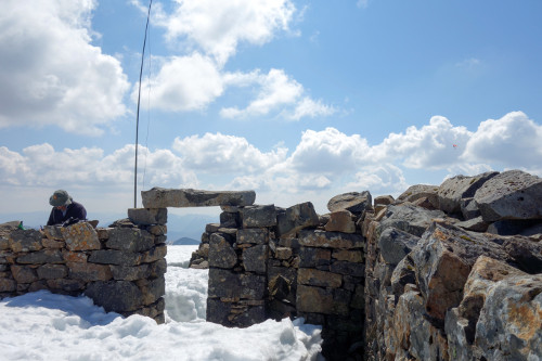
Radio operator on the summit of Ben Nevis
Down in the valley again, I spotted a nice opportunity for a bath; very welcome after the days out in remote places. The River Nevis was even quite warm, it felt much warmer than I expected.
Later the day, we restocked our food supplies and caught the train towards Glasgow and decided to get out at a random stop in order to pitch the tent for a last time.
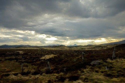
Gloomy atmosphere over Rannoch Moor
We passed Rannoch which might have made a good spot, but because of the friendly time of the morning train, we decided to go to Upper Tyndrum – unaware that it was a narrow entrance to the Highlands where A82, the railway line to Mallaig, and the railway line to Oban meet. Hence, this tent site became a bit noisier than expected (also thanks to the late evening Royal Airforce fighter zooming around) and less scenic than I imagined. Anyways, we discovered the remnants of a former lead crushing plant where the West Highland Way meets Tyndrum – the soil is poisoned and nothing will grow there anymore; a desolate site showing some of Tyndrum’s history.
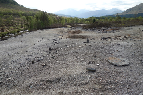
Poisoned soil at the site of a former lead crushing plant
Day 8: Back to Edinburgh
Enjoying yet another train ride back on yet another sunny day. We reached Edinburgh where Peter and I devoted a lot of time to eating (necessary), some touring of the town (sunny), and watching a dramatic football game between Falkirk and Hibernian.
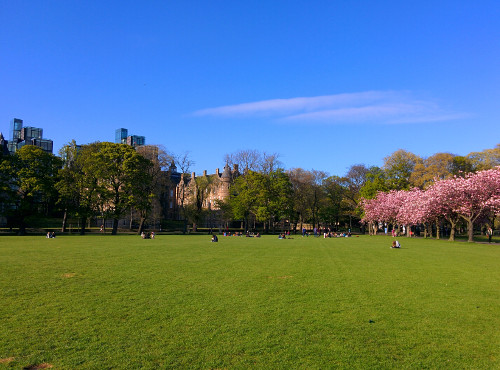
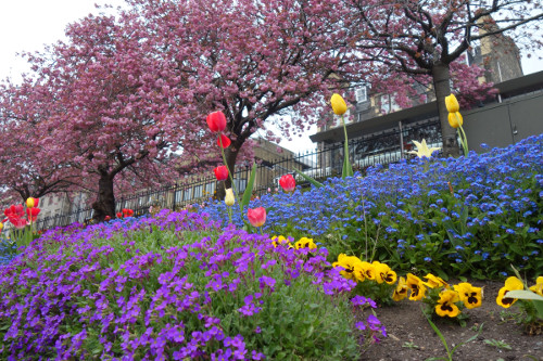
Spring feeling at the Meadows in Edinburgh
Welcome to Scotland.
References
[1] Checklist Manifesto by Atul Gawande: http://atulgawande.com/book/the-checklist-manifesto/[2] Great Mountain Days in Scotland: 50 Classic Hillwalking Challenges by Dan Bailey (Google Books)
[3] http://www.cuhwc.org.uk/page/meanings-gaelic-words-commonly-seen-hill-names
Gallery