11. August 2013
Across Sweden from Kungshamn to Stockholm by Bike
 Across Sweden with the bike from the west coast to the east coast? I have tried my luck. In a diary-style series of articles I will describe some of my experiences during the five days of biking In the hope that it might benefit others with similar ideas!
Motivation
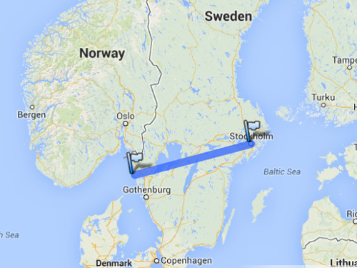
The very initial idea was not mine, but simple: cycle from Kungshamn on the west coast to Stockholm on the east coast of Sweden. A pretty good summary of idea is given by the following Google Maps screenshot showing the starting point in Kungshamn to the left and the finish line in Stockholm to the right:
The very initial response to such an idea might be: why would someone want to do that? For my part, I was looking for a challenge during my semester holidays and also for some contrast to my activities during the semester. The circumstances were excellent as I spent a study-related weekend before the bicycle trip in Kungshamn.
Route
The distance between Kungshamn and Stockholm by car is around 500 km, which serves as a lower bound for the distance to be covered with the bike. At the end, I cycled around 650 km from the start to the finish. The route went mostly through billowing landscape. I reconstructed the route on Google Maps from my notes, my maps, and my memory as I had no electronic equipment with me except than an old-school mobile phone, a watch, bicycle lighting, and a camera. Except for some details, the reconstructed route is supposed to be pretty accurate though:
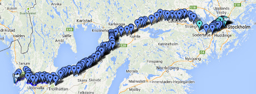
Before beginning the trip, I sketched the route roughly by making decisions on which side to pass the three big lakes along the way: Vänern on the south, Hälmaren on the north, and Mälaren on the south. I made the remaining path-planning rather ad-hoc while on the road. Thus, I had no specific itinerary. Rather I cycled every day as long as I was motivated and only during daylight. I ended up with finishing the whole trip in five days, camping near Vänersborg, near Mariestad, near Mullhyttan, and in Torshälla before reaching Stockholm on the fifth day. Here is my post-hoc itinerary (rounded towards the nearest larger settlement):
| Day | From | To | Distance |
| 1 | Kungshamn | Vänersborg | 127 km |
| 2 | Vänersborg | Mariestad | 115 km |
| 3 | Mariestad | Mullhyttan | 115 km |
| 4 | Mullhyttan | Torshälla | 137 km |
| 5 | Torshälla | Stockholm | 152 km |
Navigation
Three sources were helpful for navigating my way through the sparsely populated Sweden: bicycle maps, road signs, and GPS-enabled Google Maps on my mobile phone. Depending on the situations, some of the sources proved to be much more useful than others.
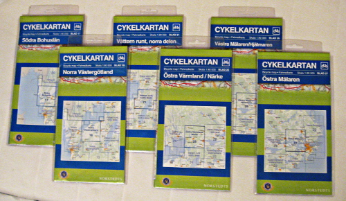
I bought the bicycle maps from Norstedt in the scale of 1:90.000, which is a compromise between weight and richness of details. I have no idea whether there are more detailed bicycle maps as those from Norstedt. The maps were quite current from all what I have seen and show many more names of places than e.g. on Google Maps. However, I could not reliably guess the elevation profile as the scale was too small for contour lines and except for shadows there was only context which allowed me to infer on the elevation profile for certain route segments. Also, I have to note that there were strange gaps between two adjacent bicycle maps. Here is a picture of the bicycle maps (map numbers 17, 18, 21, 15, 26, 27):
The road signs for cars were a very reliable source. I went on a few bicycle paths here and there which are signposted. However, the sparsity of the signs and the rather unintuitive layout and the sometimes missing destination made the signposts along the bicycle paths less useful than I originally hoped. While the signposts were a great tool when travelling through the country-side, the tracks very easy to lose in urban areas. Therefore, whenever I got impatient, I navigated by GPS through urban areas in order to avoid excessive zig-zagging in towns. But there weren’t so many towns along the route anyway.
Equipment
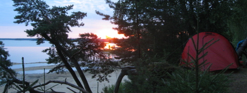
Ad-hoc route planning was feasible mainly because I had my tent with me and therefore never had to look for accommodation. Instead, I was only looking for nice spots to put up my tent but had always the backup plan to put my tent almost anywhere along the route.
Food and beverages were more difficult because I did not want to carry it around for a long time. At the same time, the grocery stores are very sparsely distributed along the route as compared to any route chosen in Germany. Hence, good timing was necessary to buy food for dinner and breakfast at the latest moment possible but no later than that.
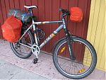
The most important equipment was of course the bike. I took my no-frills, solid mountain bike with me after having repaired it and having it repaired such that it was in good condition. After all, a broken bicycle in places where it is already hard to find a grocery store would have been a major show stopper.
For the remaining equipment, weight was the thing that mattered most. Every kilogram was noticeable when struggling with a hill.
Take-away
Was it worth it? Every minute. After having spent a lot of time in Stockholm, this trip enabled me to look into more remote corners of Sweden. I could also take advantage of Allemansrätten (translate to something as “freedom to roam”) which allowed me to find the most awesome camping spots in my life so far.